Introduction
Dimitris Plantzos
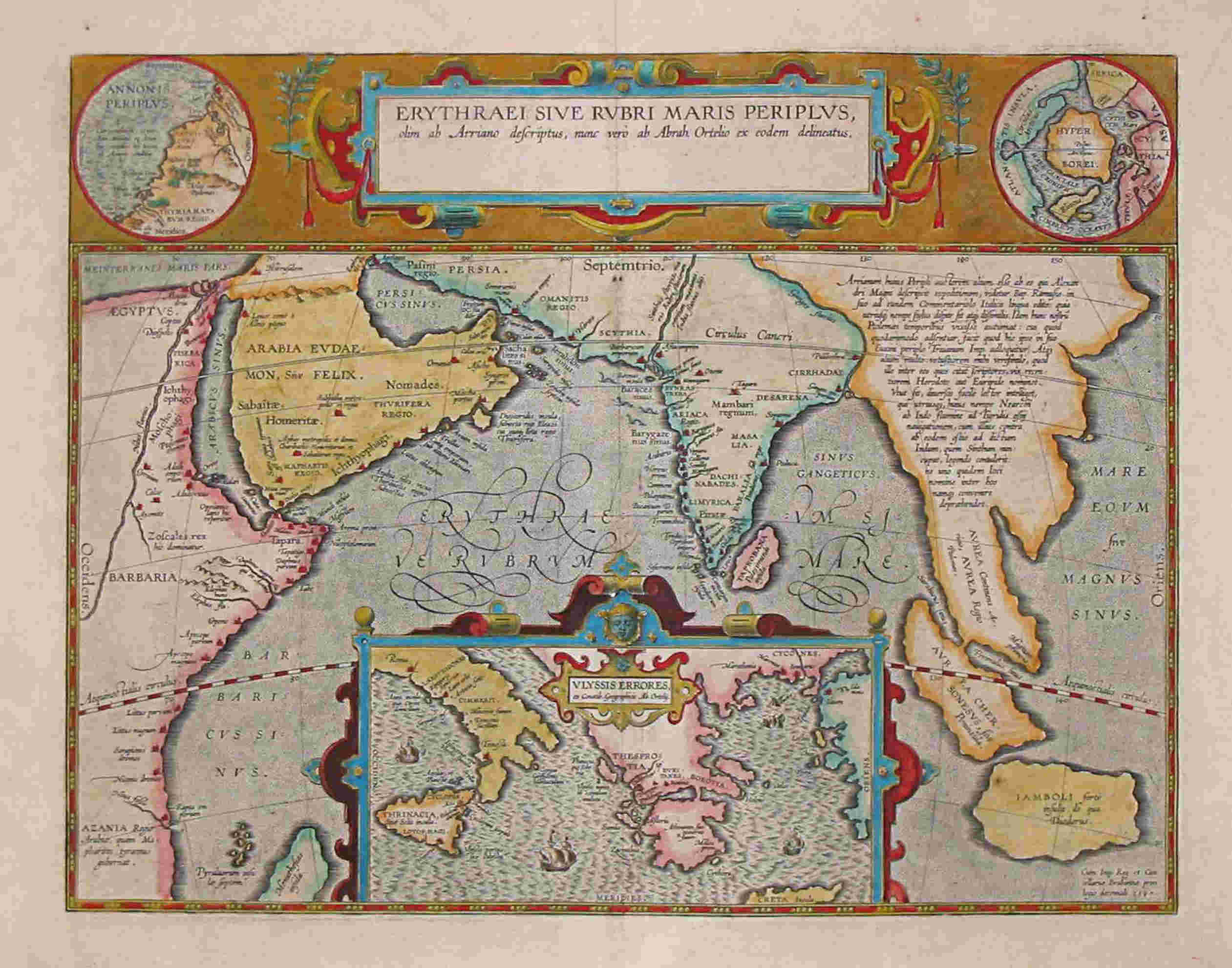
The Periplus of the Red Sea (Lat.: Periplus Maris Erythraei), is a relatively short text of the early imperial times, recording sea routes and the possibility for trade from Egyptian trading ports such as Berenice "the Troglodyte" along the Red Sea coast, and others by the Horn of Africa, the Persian Gulf, the Arabian Sea, and the Indian Ocean, including what is now Pakistan's Sindh region as well as parts of southwestern India.
The text, written in an undemanding Greek koine idiom, has been dated to various times between the 1st and 3rd centuries CE, but a mid-1st century CE date is now the most commonly accepted. Although the author remains unknown, this is someone who clearly visited the regions and the emporia (trading ports) he describes, as he seems familiar enough with the area to provide accurate information about what the ancient Greek world of the 1st century CE knew for the lands around the Indian Ocean.
Erythraia or the Red Sea was an ancient geographical designation that included the Gulf of Aden between so-called “Arabia Felix” (present-day Yemen) and the Horn of Africa, and at times (as in this particular Periplus) was extended to include the present-day Red Sea, the Persian Gulf, and the Indian Ocean as a single sea area.
The 10th-century Byzantine manuscript that forms the basis for the text we have today attributes the work to Arrian (Lucius Flavius Arrianus, 95-175 CE), the Greek author, historian, and geographer, best known for the works Anabasis of Alexander and Indica. But this does not seem to be true; on the contrary, ancient tradition also attributes to the same author other geographical works that do not seem to belong to him either.
Initially, the text of the Periplus was handed down only by a manuscript of the 14th-15th century, which is kept in the National Library of Great Britain. It was edited by Sigmund Gelen, and first published by Hieronymus Froben in 1533. As we know today, this manuscript was a corrupted copy of the 10th century Byzantine manuscript already mentioned, which had been transferred from Heidelberg to Rome in the 17th century, and thence to Paris in the Napoleonic years, to return to Heidelberg in 1816.
Wilfred Harvey Schoff, who published the text in 1912, dated it to 59-62 CE, attributing it to an “Egyptian Greek, Roman citizen”. Schoff considered the author of the text to be “not highly educated” and speculated that he himself resided in Berenice rather than Alexandria or some other metropolitan centre in the region.
In 1989, the text was republished by Lionel Casson, who dated it to 40-70 CE while in 2009 John Hill dated the Periplus to the period 40-50 CE.
The Periplus consists of 66 passages, most of which do not exceed five or six lines. The reference to places, geographical landmarks, cities, ports, etc. is laconic, with the aim of providing useful information for the facilitation of navigation, as well as the safety of crews and goods. In many cases, the description of the sites is accurate enough to be identified on the map by today’s scholars. At other times, the generalities provided by the text are confusing. For example, the site “Rhapta” is listed as the most distant trading port down the African coast of “Azania” (§ 16), but there are several sites that would fit the description, located from the city of Tanga to the area south of the Rufiji River Delta in present-day Tanzania. The description of the Indian coast, on the other hand, clearly mentions the river Ganges, but after that it becomes quite vague, describing China as a “great inland city called Thina”, and a source of raw silk (§ 64).
The text also mentions, usually incidentally, some particularly interesting facts, such as for example that the first sailor who crossed the Indian Ocean directly from the Red Sea to the Indian peninsula without traveling along the coast as was done for safety reasons was the Greek navigator of the 1st century BCE Hippalos, or the observation that the south-eastern coast of Africa, in its extension to the south, gradually meets the “western sea” (§ 18), that is our own Atlantic Ocean.
Also of particular interest are the concise, and often repeated, lists of raw materials and other commodities which, according to the text, are available in the various trades along the coasts described. These may involve relatively common raw materials (e.g. tin, iron), textiles and clothing, exotic spices and herbs (such as pepper or cinnamon), cosmetic or medicinal substances (such as nardos, often identified with valeriana, or the fragrant malavathron), rare resins and various other types of incense that at the time were considered materials of luxury and prestige (myrrh, smyrna, styrax), precious stones and pearls, but also slaves (which the author usually calls dimply “bodies”).
Many of the terms used to describe raw materials and luxuries are found only here, resulting in confusion as to interpretation or the inability of today’s scholar to identify precisely what material is being referred to. For example, in the region of Arabia, it is mentioned that the traders there trade, among other things, “duaka”, but this material is unknown to us, (§ 8). On the contrary, a little further north, and along the African coast, it is mentioned (§ 6) that “colour lac” is sold, a material not reported elsewhere, but which seems to correspond to the late medieval Latin lacca, a term probably borrowed from the medieval Arabic lakk, which in turn comes from the Sanskrit lakh, meaning a red resin native to India used as a red pigment and as a varnish (corresponding to today’s: lacquer).
The route described in the text starts from the port of Myos Ormos (Oyster Bay) in northeastern Egypt, which was built in the 3rd century BCE by the Ptolemies, and is identified with today's Quseir al-Quadim. Next comes Berenice Troglodytike or Baranis, one of the most important ports of the Greco-Roman world. Following the course towards the Horn of Africa, we meet Opone, which is identified with the Ras Hafun site in present-day Northern Somalia. During antiquity, Opone was an important stop for traders from Phoenicia, Egypt, Greece, Persia, Arabia, Africa, and many other regions of the Roman Empire, as it was strategically located on the sea between Azania (in the central Africa) and the Red Sea. It even attracted traders from Indonesia and Malaysia, who sold spices, precious stones, silk, and other exotic luxuries. At the time the Periplus was written, around 50 CE, Opone was leading the trade in cinnamon, cloves, and other spices, as well as ivory, skins of rare wild animals, and incense.
Essentially circumnavigating the Arabian Peninsula, Periplus focuses more on its southern coast, and the cities of Musa, Arabia Felix, and Cane (present-day Bi’r Ali, in the Hadhramaut region of South Arabia) that he encounters there. In these cities, and especially in Cane, the international trade in frankincense and incense was carried out at that time (most commonly resins of trees or shrubs with a strong aroma, which in ancient times had sedative or even narcotic uses, but were also used in religious rituals, just as they are today). The emphasis on the frankincense trade gave the area the nickname "Frankincense kingdom", to which the text of the Periplus also refers.
Finally, an important place in the text is occupied by Barygaza, an ancient trading post identified with the present-day city of Baruch in western India. Barygaza was a trading hub for the wider region, connecting the Indian hinterland with the sea routes leading to the Horn of Africa and Egypt, and from there – via Alexandria – across the Mediterranean. The Periplus mentions numerous items that were traded through Barygaza, from metals (copper, tin, lead) and precious stones to perfumes, incense, and spices, textiles and clothing, but also slaves. It is also mentioned that goods from the Mediterranean, such as Italian wine, also arrived there, to be taken to Arabia and India.
From the text of the Periplus, and the information provided by the author, it is inferred that the voyages to the western coasts of the Indian peninsula were conducted exclusively in the monsoon season: the ships left Egypt in the month of July, so as to take advantage of the south-west winds which were blowing at that time, and so to reach India safely in the month of September. If they left the coast of Africa earlier, in the month of June, they risked reaching the coast of India in the month of August, when the weather conditions were particularly dangerous for navigation. For the return to Egypt, the sailors had to take advantage of the northeast winds, which blow during the period between December and January of each year.